

Product Description
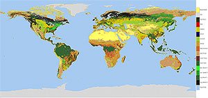 The One-Minute Land Ecosystem Classification Product is a global (static map) data set of the International Geosphere-Biosphere Programme (IGBP) classification scheme
stored on an equal-angle rectangular grid at 1-minute resolution. The dataset is generated from the official MODIS land ecosystem classification dataset, MOD12Q1
for year 2000, day 289 data (October 15, 2000).
The One-Minute Land Ecosystem Classification Product is a global (static map) data set of the International Geosphere-Biosphere Programme (IGBP) classification scheme
stored on an equal-angle rectangular grid at 1-minute resolution. The dataset is generated from the official MODIS land ecosystem classification dataset, MOD12Q1
for year 2000, day 289 data (October 15, 2000).
This dataset is used in generating the spatially complete albedo maps and statistics, but is also a stand-alone product designed for use by the user community.
Methodology
The One-Minute Land Ecosystem Classification Product is generated from the official MODIS Ecosystem product, MOD12Q1, by remapping the IGBP classification scheme
from an Integerized Sinusoidal (ISIN) projection to equal-angle rectangular coordinates at 1-minute resolution
(2 km at the equator, < 1 km at the pole). The MOD12Q1 Quality Assurance (QA) is then applied to the remapped data.
Additional Information
Coverage: Global
Spatial Characteristics: Equal-angle rectangular oordinates at 1-minute resolution (2 km at equator, < 1 km at pole).
Temporal Characteristics: Static, generated from Julian Day 289, 2001 data.
Key Science Applications: GCM, energy balance, land use and land use change, biophysical, oceanographic, and meteorological studies.
Key Geophysical Parameters: IGBP Ecosystem Classification Scheme.
Processing Level: 3
Product Type: Unofficial, Derived, Value-Added, Ancillary
Maximum File Size: 1.1GB
File Frequency: 1 File.
Primary Data Format: HDF
|