

Product Description
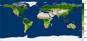 The Filled Normalized Difference Vegetative Index (NDVI) Product, which is computed from the (White-Sky) Filled Land Surface Albedo Map Product,
is a global data set of spatially complete NDVI maps for 23 sixteen-day periods per year (001, 017, ... 353).
There are two types of Filled NDVI Products: 1-minute Map Products and coarser resolution Statistical Products.
The Filled Normalized Difference Vegetative Index (NDVI) Product, which is computed from the (White-Sky) Filled Land Surface Albedo Map Product,
is a global data set of spatially complete NDVI maps for 23 sixteen-day periods per year (001, 017, ... 353).
There are two types of Filled NDVI Products: 1-minute Map Products and coarser resolution Statistical Products.
Map Products, containing spatially complete NDVI data, are generated at 1-minute resolution on an equal-angle grid.
Statistical Products, computed from the Filled NDVI Map Product (outlined above),
contain simple statistics (mean, standard deviation, and pixel counts)
generated on equal-angle grids at various coarser resolutions (½, 1, 2, 3, 4, 5, and 10°).
It should be noted that these products currently exist for year 2001 (Terra) data only.
Year 2002 (Terra) data is being prepared for release in early 2004.
Methodology
NDVI can be defined as the following ratio of albedos (α) at different wavelengths:
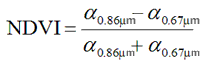
The global maps of NDVI are produced by computing this ratio from the specific wavelengths of the spatially complete white-sky albedo maps and statistics are subsequently generated by binning the 1-minute NDVI maps at various resolutions.
The binning grid is equal-angle and cell-centered such that for a 1° grid
the upper left corner grid box contains data from 90 to 89°N latitude and
180 to 179°W longitude.
Additional Information
Coverage: Global
Temporal Characteristics: 16-day periodicity.
Key Science Applications: GCM, energy balance, land use and land use change, biophysical, oceanographic, and meteorological studies.
Key Geophysical Parameters: NDVI
Processing Level: 3
Product Type: Unofficial, Derived, Value-Added, Ancillary
Primary Data Format: HDF
- Filled NDVI Map Product
Spatial Characteristics:
Equal-Angle Rectangular Coordinate grid, 1-minute resolution (2 km at equator, < 1 km at pole)
Maximum File Size:
1 Map Product File = 445 MB
File Frequency:
1 Map Product File/Day
- Filled NDVI Statistical Product
Spatial Characteristics:
Equal-Angle Rectangular Coordinate grid, at various resolutions (½ to 10°)
Maximum File Size:
½° Statistical Product File = 40 MB
(coarser resolution files are significantly smaller)
File Frequency:
1 Statistical Product File/Day/Resolution
|