 |

Product Description
The MODIS Cloud Mask product is a Level 2 product generated at
1-km and 250-m (at nadir) spatial resolutions. The algorithm
employs a series of visible and infrared threshold and
consistency tests to specify confidence that an unobstructed
view of the Earth's surface is observed. An
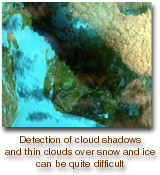
indication of shadows affecting the scene is also provided.
The 250-m cloud-mask flags are based on the
visible channel data only. Radiometrically accurate
radiances are required, so holes in the Cloud Mask
will appear wherever the input radiances are incomplete
or of poor quality.
There are two MODIS Cloud Mask data product files:
MOD35_L2, containing data collected from the Terra platform; and
MYD35_L2, containing data collected from the Aqua platform.
Research and Application
A determination of the presence of global cloudiness
is essential to the MODIS mission for two reasons.
First, clouds play a critical role in the radiative balance
of the Earth and must be accurately described
to assess climate and potential climate change. Second,
the presence of cloudiness must be accurately
determined to retrieve properly many atmospheric
and surface parameters. For many of these retrieval
algorithms even thin cirrus represents contamination.
Data Set Evolution
The MODIS cloud-mask algorithm employs a battery
of spectral tests, which use methodology applied
for the AVHRR Processing scheme Over cLoudy Land
and Ocean (APOLLO), International Satellite Cloud
Climatology Project (ISCCP), CLoud Advanced Very
high resolution Radiometer (CLAVR), and Support
of Environmental Requirements for Cloud Analysis
and Archive (SERCAA) to identify cloudy FOVs.
From these a clear-sky confidence level (high confident
clear, probably clear, undecided, cloudy) is assigned
to each FOV. For inconclusive results, spatial-
and temporal-variability tests are applied. The
spectral tests rely on radiance (temperature) thresholds
in the infrared and reflectance thresholds in the
visible and near-infrared. Thresholds vary with surface
type, atmospheric conditions (moisture, aerosol,
etc.), and viewing geometry. Along with MOD02
calibrated radiances, a 1-km land/water mask, DEM,
ecosystem analysis, snow/ice cover map, NCEP
analysis of surface temperature and wind speed, and
an estimate of precipitable water will be required as
inputs.
Cloud-mask validation will be conducted using
MAS data from several field campaigns, all-sky cameras,
and comparison with NOAA operational instruments
and, possibly, Terra instruments such as ASTER
(see Volume 1).
Additional Information
Coverage: Global
Spatial/Temporal Characteristics: 250 m and
1 km/daily
Key Science Applications: Cloud determination
and screening, climate modeling, climate
monitoring, increasing accuracy of other
MODIS retrievals
Key Geophysical Parameters: Presence of
cloud or shadow
Processing Level: 2
Product Type: Standard, at-launch
Maximum File Size: 48 MB
File Frequency: 288/day
Primary Data Format: HDF-EOS
|