

Product Description
The MODIS Aerosol Product monitors the ambient aerosol optical thickness over the oceans
globally and over a portion of the continents. Further,
the aerosol size distribution is derived over the
oceans, and the aerosol type is derived over the continents.
Daily Level 2 data are produced at the spatial resolution of a 10x10 1-km (at nadir)-pixel array.
There are two MODIS Aerosol data product files:
MOD04_L2, containing data collected from the Terra platform; and
MYD04_L2, containing data collected from the Aqua platform.
Research and Application
Aerosols are one of the greatest sources of uncertainty
in climate modeling.
Aerosols vary in time in space and can lead to variations in cloud
microphysics, which could impact cloud radiative properties and climate.
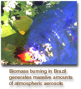
The MODIS aerosol product is used to study aerosol climatology, sources
and sinks of specific aerosol types (e.g., sulfates and
biomass-burning aerosol), interaction of aerosols with
clouds, and atmospheric corrections of remotely
sensed surface reflectance over the land.
Data Set Evolution
Prior to MODIS, satellite measurements were limited
to reflectance measurements in one (GOES,
METEOSAT) or two (AVHRR) channels. There was
no real attempt to retrieve aerosol content over land
on a global scale. Algorithms had been developed
for use only over dark vegetation. The blue channel
on MODIS, not present on AVHRR, offers the possibility
to extend the derivation of optical thickness
over land to additional surfaces. The algorithms will
use MODIS bands 1 through 7 and 20 and require
prior cloud screening using MODIS data. Over the
land, the dynamic aerosol models will be derived from
ground-based sky measurements and used in the net
retrieval process.
Over the ocean, three parameters that describe the
aerosol loading and size distribution will be retrieved.
Pre-assumptions on the general structure of the size
distribution are required in the inversion of MODIS
data, and the volume-size distribution will be described
with two log-normal modes: a single mode
to describe the accumulation mode particles
(radius < 0.5 µm) and a single coarse mode to describe dust
and/or salt particles (radius > 1.0 µm). The aerosol
parameters we therefore expect to retrieve are: the
ratio between the two modes, the spectral optical
thickness, and the mean particle size.
The quality control of these products will be based
on comparison with ground stations and climatology.
Additional Information
Coverage: Global over oceans, nearly global over land
Spatial/Temporal Characteristics: 10 km for Level 2
Key Science Applications: Aerosol climatology,biomass-burning aerosols, atmospheric corrections, cloud radiative properties, climate modeling
Key Geophysical Parameters: Atmospheric aerosol optical depth (global) and aerosol size distribution (oceans)
Processing Level: 2
Product Type: Standard, at-launch
File Frequency: 144/day
Data Format: HDF
|