 |

Level-2 MODIS Atmosphere Products
There are six Level-2 (Orbital Swath) MODIS Atmosphere products collected from two platforms:
the Terra platform and the Aqua platform. Each product is
assigned an 8-character Earth Science Data Type (ESDT) name, given below,
which is used in cataloging and archiving the datasets.
The Level-2 MODIS Atmosphere products are:
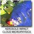 1. The Aerosol Product
monitors aerosol type, aerosol optical thickness,
particle size distribution, aerosol mass concentration,
optical properites, and radiative forcing.
The ESDT names are
MOD04_L2 (Terra) and
MYD04_L2 (Aqua).
1. The Aerosol Product
monitors aerosol type, aerosol optical thickness,
particle size distribution, aerosol mass concentration,
optical properites, and radiative forcing.
The ESDT names are
MOD04_L2 (Terra) and
MYD04_L2 (Aqua).
 2. The Water Vapor Product
monitors atmospheric water vapor and precipitable water.
The ESDT names are
MOD05_L2 (Terra) and
MYD05_L2 (Aqua).
2. The Water Vapor Product
monitors atmospheric water vapor and precipitable water.
The ESDT names are
MOD05_L2 (Terra) and
MYD05_L2 (Aqua).
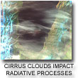 3. The Cloud Product
monitors the physical and radiative properties of clouds
including cloud particle phase (ice vs. water, clouds vs. snow),
effective cloud particle radius, cloud optical thickness, cloud
shadow effects, cloud top temperature, cloud top height, effective
emissivity, cloud phase (ice vs. water, opaque vs. non-opaque),
and cloud fraction under both daytime and nighttime conditions.
The ESDT names are
MOD06_L2 (Terra) and
MYD06_L2 (Aqua).
3. The Cloud Product
monitors the physical and radiative properties of clouds
including cloud particle phase (ice vs. water, clouds vs. snow),
effective cloud particle radius, cloud optical thickness, cloud
shadow effects, cloud top temperature, cloud top height, effective
emissivity, cloud phase (ice vs. water, opaque vs. non-opaque),
and cloud fraction under both daytime and nighttime conditions.
The ESDT names are
MOD06_L2 (Terra) and
MYD06_L2 (Aqua).
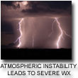 4. The Atmosphere Profile Product
monitors profiles of atmospheric temperature and moisture,
atmospheric stability, and total ozone burden.
The ESDT names are
MOD07_L2 (Terra) and
MYD07_L2 (Aqua).
4. The Atmosphere Profile Product
monitors profiles of atmospheric temperature and moisture,
atmospheric stability, and total ozone burden.
The ESDT names are
MOD07_L2 (Terra) and
MYD07_L2 (Aqua).
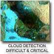 5. The Cloud Mask Product
indicates whether a given instrument field of view (FOV) of
the Earth's surface is unobstructed by clouds or affected by cloud shadows.
The cloud mask also provides additional information about the FOV including
the presence of: cirrus clouds, ice/snow, and sunglint contamination. Finally
flags denoting day/night and land/water are included.
The ESDT names are
MOD35_L2 (Terra) and
MYD35_L2 (Aqua).
5. The Cloud Mask Product
indicates whether a given instrument field of view (FOV) of
the Earth's surface is unobstructed by clouds or affected by cloud shadows.
The cloud mask also provides additional information about the FOV including
the presence of: cirrus clouds, ice/snow, and sunglint contamination. Finally
flags denoting day/night and land/water are included.
The ESDT names are
MOD35_L2 (Terra) and
MYD35_L2 (Aqua).
6. The post-launch Joint Atmosphere Product
contains a spectrum of key parameters gleaned from the complete set of standard at-launch Level 2 products:
Aerosol, Water Vapor, Cloud, Profile, and Cloud Mask.
The Joint Atmosphere product was designed to be small enough to minimize data transfer and storage requirements,
yet robust enough to be useful to a significant number of MODIS data users.
Scientific data sets (SDS's) contained within the Joint Atmosphere product cover a full set of high-interest parameters
produced by the MODIS Atmosphere group, and are stored at 5-km and 10-km (at nadir) spatial resolutions.
The ESDT names are
MODATML2 (Terra) and
MYDATML2 (Aqua).
Level-3 MODIS Atmosphere Products
There are three Level-3 (Global Gridded) MODIS Atmosphere products collected from two platforms.
Each of the Level-3 products contain statistics generated from the first four Level-2 products noted above.
Statistics are summarized over a 1x1 degree global grid for daily, eight-day, and monthly temporal periods.
The Level-3 MODIS Atmosphere products are:
1. The Daily Global Joint Product
contains roughly 600 statistical datasets derived from Level-2 MODIS
Atmosphere parameters that are summarized over a 24-hour (00 to 00 GMT) period.
The ESDT names are
MOD08_D3 (Terra) and
MYD08_D3 (Aqua).
2. The Eight-Day Global Joint Product
contains roughly 800 statistical datasets derived from Level-2 MODIS
Atmosphere parameters that are summarized over an 8-day period.
The ESDT names are
MOD08_E3 (Terra) and
MYD08_E3 (Aqua).
3. The Monthly Global Joint Product
contains roughly 800 statistical datasets derived from Level-2 MODIS
Atmosphere parameters that are summarized over a monthly period. It should be noted that
the content of this product is identical to the Eight-Day Global Joint Product,
except for the time period covered.
The ESDT names are
MOD08_M3 (Terra) and
MYD08_M3 (Aqua).
|