|

|
Tracking of known problems and subsequent fixes is an important issue for MODIS data users.
This page will act as a repository of all known MODIS Atmosphere Data Product problems,
as well as how to determine the problematic version (and the fixed version) of the HDF data --
therefore data users should check this page for updates regularly.
Data Users unfamiliar with how to properly track problems and fixes by determining the version of their downloaded HDF files
should refer to the documentation at the bottom of this page.
|
|
|
Collection 006 Issues
Click the colored buttons below for the known problems associated with each MODIS Atmosphere Data Product in Collection 6.


- Issue with Sampling of "potentially paired" SSH files
 Description:
For some scientific studies, some users might wish to pair SSH files with ATML2 files. MOD02SSH files contain subsampled geolocation (latitude and longitude) and solar and sensor angles from the MOD03 files, as well as subsampled Earth view radiance/reflectance and uncertainty indexes from the L1B files. Due to a coding error in the SSH code, the subsampled geolocation in the SSH (which was incorrectly specified) does not match the subsampled geolocation in the ATML2 (which was correctly specified), a problem that affects both Terra and Aqua MODIS.
Description:
For some scientific studies, some users might wish to pair SSH files with ATML2 files. MOD02SSH files contain subsampled geolocation (latitude and longitude) and solar and sensor angles from the MOD03 files, as well as subsampled Earth view radiance/reflectance and uncertainty indexes from the L1B files. Due to a coding error in the SSH code, the subsampled geolocation in the SSH (which was incorrectly specified) does not match the subsampled geolocation in the ATML2 (which was correctly specified), a problem that affects both Terra and Aqua MODIS.
The ATML2 sampling (correctly) starts at column 3, row 4 in the 1km geolocation data, but the SSH sampling (incorrectly) starts at column 4, row 3. It appears that the sampling changes that were made for C6 to align the SSH and ATML2 sampling, and to sample the working Aqua detectors, did not get applied to the SSH geolocation SDSs. Users should also note that the solar and sensor angles (zenith and azimuth) in the SSH are sampled consistent with the SSH geolocation, and are thus also incorrect.
Advice to Users:
When pairing SSH and ATML2 files, users should point to (use) the ATML2 for the correct geolocation (latitude and longitude) information, and ignore or bypass the geolocation in the SSH files. However, the angle SDSs are unfortunately only available in the SSH files. Because the sampling differences are only a single pixel (1km at nadir) in the x and y horizontal directions, this disconnect is not expected to have a significant impact on results obtained by pairing these two datasets, but it does exist and introduces a discontinuity.
Impact: Low
Data Dates Affected: All data since launch.
Platform Affected: Both Terra and Aqua
|

|
|

|
|
PGE Version
|
Production Dates
|
|
PGE Version
|
Production Dates
|
|
All
|
All
|
|
Not Corrected
|
Not Corrected
|
Problems in input 04_L2, 05_L2, 06_L2, 07_L2, and 35_L2 propagate into ATML2
|
Description:
See the Known Problem pages for the input Level-2 products 04_L2 (Aerosol), 05_L2 (Water Vapor), 06_L2 (Cloud),
07_L2 (Profiles), and 35_L2 (Cloud Mask) by clicking on the links or the colored tabs above.
|
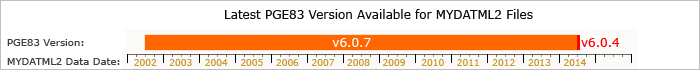
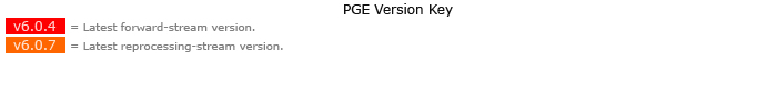
Latest PGE Version Available (by Data Date)
How to Track MODIS Data File "Versions" (Important for Tracking Problems and Fixes)
Problems and fixes in MODIS Atmosphere Product HDF files can be tracked in one of two ways:
- the Product Generation Executive (PGE) Version Number that can be queried from any HDF file using the command:
ncdump -h *.hdf
- the HDF File "Production Date".
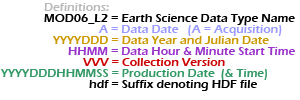
The HDF File "Production Date", which is the date the HDF file was actually generated or produced, can be found in the HDF filename itself (shown in green color below):
Level 2 Product Names:

|
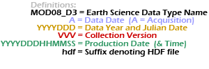
Level 3 Product Names:

|
|
Note that 1.) all times are UTC time, not local time 2.) the DDD in the date denotes the Julian Date (001-366), and 3.) the MOD06_L2 (or MOD08_D3) prefix is only an example (MYD04_L2, MOD05_L2, MYD05_L2, MYD06_L2, etc. ... or MYD08_D3, MOD08_E3, MYD08_E3, MOD08_M3, MYD08_M3 could be substituted).
|
|