MODIS Atmosphere
MODIS Atmosphere Home Products  Images  Validation  News  Staff  Forum  Reference  Tools  Help
Aerosol Product  Water Vapor Product  Cloud Product  Atmosphere Profile Product  Cloud Mask Product   Joint Atmosphere ProductLevel-2 Products
Daily Global Product  Eight-Day Global Product  Monthly Global ProductLevel-3 Products       Filled Land Surface Albedo ProductFilled Normalized Difference Vegetative Index ProductOne-Minute Land Ecosystem Classification ProductLevel-3 Ancillary Land Surface Products
VALIDATION
04_L2 Known Problems
05_L2 Known Problems
06_L2 Known Problems
07_L2 Known Problems
35_L2 Known Problems
ATML2 Known Problems
08_D3 Known Problems
08_E3 Known Problems
08_M3 Known Problems

Known Problem Summary

Tracking of known problems and subsequent fixes is an important issue for MODIS data users. This page will act as a repository of all known MODIS Atmosphere Data Product problems, as well as how to determine the problematic version (and the fixed version) of the HDF data -- therefore data users should check this page for updates regularly. Data Users unfamiliar with how to properly track problems and fixes by determining the version of their downloaded HDF files should refer to the documentation at the bottom of this page.      

Collection 006 Issues

Click the colored buttons below for the known problems associated with each MODIS Atmosphere Data Product in Collection 6.

Click to see 04_L2 Known Problems Click to see 05_L2 Known Problems Click to see 06_L2 Known Problems Click to see 07_L2 Known Problems Click to see 35_L2 Known Problems Click to see ATML2 Known Problems Click to see 08_D3 Known Problems Click to see 08_E3 Known Problems Click to see 08_M3 Known Problems


  • MOD35 (Terra Cloud Mask) False Clouds over Ocean (Impact of the MODIS Terra Band 29 (8.6 µm) radiometric calibration drift on cloud products)

    Updated Description: The Terra spacecraft and instruments went into safe hold from 2016-02-18 through 2016-02-22. On 2016-04-08, Terra MODIS Collection 5 (C5) and Collection 6 (C6) Atmosphere forward processing and distribution via LAADS was restarted from data day 2016 059 (Feb 28th 2016).

    The MODIS Characterization and Support Team (MCST) has made post-safe mode radiance calibration adjustments to the L1B (MOD02) code. However, degraded detector performance in Terra MODIS Band 27 (6.7 um) and Band 29 (8.6 um) necessitated algorithm changes to the L2 cloud mask (MOD35) and the L1B de-striper code used in the production of the L2 atmospheric profile (MOD07/05) and cloud-top (MOD06) products. Specifically, cloud mask thresholds were adjusted to remove false positives for the 6.7 um brightness temperature (BT) test for high clouds and the 8.6-11 um BTD test over the ocean, while reference detectors in the de-striper code were modified to avoid noisy detectors.

    Users are advised that further testing is needed to re-validate the current forward stream for the above products (and also down stream products, e.g., MOD06 cloud optical properties and Level-3 Daily, Eight-Day, and Monthly) and to document the impact (if any) of these combined sensor and algorithm changes on the use of MODIS Terra atmosphere team products for climate studies.

    We previously noted that Band 29 detector crosstalk degradation resulted in artificially high cloud cover over tropical oceans in recent years. The post-safe mode adjusted threshold for the 8.6-11 um BTD test is expected to reduce the impact on cloud fraction. Therefore, the climate continuity record is broken, specifically cloud mask (i.e., fractions) and to a varying extent the downstream products such as cloud top, IR phase, and optical properties.


    Initial Description: In early 2015, it was noticed that recent Terra Collection 6 (C6) cloud top pressure products (MOD06) contained ocean regions with an anonymously high incidence of low clouds. This was traced to false clouds being reported by the cloud mask (MOD35). In turn, this was found to be the result of errors in the b29-b31 brightness temperature difference (BTD) high (ice phase) cloud test. As a result, a substantial number of clear pixels were being flagged as cloudy by this test. The text that follows is a summary of the impact of the MODIS Terra Band 29 (8.6 µm) radiometric calibration drift on cloud products. MOD35 includes a spectral test using the brightness temperature difference (BTD) between band 29 (8.6 µm) and band 31 (11 µm), referred to here as the b29-b31 BTD test. This test is used only over water surfaces. The root problem is a gradual warming in the Terra MODIS b29 channel over the years, that is not being captured by the on-board calibration systems and apparently related to crosstalk issues. Monthly time series trend analysis of Terra MODIS cloud products indicates that the significance of the impact may extend back to 2010. In lieu of a successful fix to the L1B algorithm for b29, an adjustment to the 8.6-11 µm MOD35 test threshold was delivered to the production test system to quantify the impact. Testing of this potential fix in the data is ongoing as of September 2015. A fix should eventually be implemented, at which time affected data will be rerun (corrected) and made available. See the PDF document linked below for for detailed information and imagery.

    Impact: High

    Data Dates Affected: 2010 and on (but worse 2014 and on)

    Platform Affected: Terra Only

     
    PGE Version Production Dates   PGE Version Production Dates
    ≥ 2010   Correction Testing Underway Correction Testing Underway

    For more information, view this PDF document:
    Impact of MODIS Terra Band 29 (8.6 µm) radiometric calibration drift on cloud products (PDF)

  • GDAS Change Impacts

    The GDAS Model changed in January 2015, so for both Aqua and Terra MODIS products users should note:

    1. For most daytime granules, there will be no changes in the cloud mask product (MOD35) due to the new GDAS model output. There will be more changes in nighttime data due to surface temperature and total precipitable water differences but we anticipate no biases due to the new GDAS inputs.
    2. We also anticipate no significant changes to the 5-km and 1-km cloud top pressure product (MOD_PR06CT). Most changes found in the Level 2 cloud top pressures are one atmospheric pressure level that seem to be randomly distributed.


  • Cloud Mask not detecting high thick clouds over Weddell Sea (Antarctica) when ice covered

    Description: In collection 006, the cloud mask is failing to detect high thick clouds over the Weddell Sea area in Antarctica when it is ice-covered. This represents a small area over very dry conditions. This problem might be fixed in a future PGE03 delivery, until then users should be aware of this shortcoming.

    Impact: Low

    Data Dates Affected: 7/2002-current

    Platform Affected: Aqua Only

     
    PGE Version Production Dates   PGE Version Production Dates
    ≤ PGE03 v6.0.40 All   (not corrected) (not corrected)


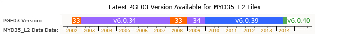
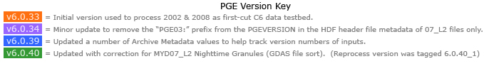
Latest PGE Version Available (by Data Date)

Shown below is a bar chart graphic summarizing the latest Product Generation Executive (PGE) Version used to produce Collection 6 (C6) 35_L2 HDF files available for public distribution (download) in the LAADS data archive. This graphical representation gives MODIS data users a summary guide (digestable at a glance) on how the PGE Version varies across the multi-year data record. Each PGE version contains a unique set of fixes and improvments and show where data quality discontinuities can occur. If MODIS data users have older versions of any of the data shown below, they should download the newer (more correct) version from either: LAADS FTP (Download C6 MYD35_L2 Data) or LAADS Web (Search & Order MODIS Data)

Aqua:


How to Track MODIS Data File "Versions" (Important for Tracking Problems and Fixes)

Problems and fixes in MODIS Atmosphere Product HDF files can be tracked in one of two ways:

  1. the Product Generation Executive (PGE) Version Number that can be queried from any HDF file using the command:
      ncdump -h *.hdf
  2. the HDF File "Production Date".

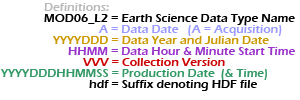
The HDF File "Production Date", which is the date the HDF file was actually generated or produced, can be found in the HDF filename itself (shown in green color below):
Level 2 Product Names:

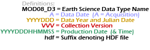
Level 3 Product Names:

Note that 1.) all times are UTC time, not local time 2.) the DDD in the date denotes the Julian Date (001-366), and 3.) the MOD06_L2 (or MOD08_D3) prefix is only an example (MYD04_L2, MOD05_L2, MYD05_L2, MYD06_L2, etc. ... or MYD08_D3, MOD08_E3, MYD08_E3, MOD08_M3, MYD08_M3 could be substituted).