MOD08_M3 product files are stored in Hierarchical Data Format (HDF).
HDF is a multi-object file format for sharing
scientific data in multi-platform distributed environments.
HDF files should only be accessed through HDF library subroutine and function calls,
which can be downloaded from the HDF web site.
Each of the gridded statistical fields within the HDF file is stored as a Scientific Data Set (SDS).
Only a subset of statistics outlined in the Statistic List (see below)
are computed for each parameter.
Monthly (08_M3) Parameter List (primary parameters only)
|
Parameters derived from the L2 Aerosol (04_L2) Product
|
|
AEROSOL: LAND & OCEAN (L.A.Remer)
|
|
Scattering_Angle
|
Derived from the 04_L2 SDS "Scattering_Angle".
|
|
Aerosol_Optical_Depth_Land_Ocean
|
Derived from the 04_L2 SDS "Optical_Depth_Land_And_Ocean".
Note that the
land part of this SDS is taken from the 04_L2 SDS Corrected_Optical_Depth_Land at 0.55 microns and the
ocean part of this SDS is taken from the 04_L2 SDS Effective_Optical_Depth_Best_Ocean
(a parameter that is not propagated into L3 by itself).
|
|
AEROSOL: LAND ONLY (L.A.Remer)
|
Aerosol_Optical_Depth_Land
|
Derived from the 04_L2 SDS "Corrected_Optical_Depth_Land".
Three solutions (computed at 0.47, 0.55, and 0.66 microns) are retained.
Note that this parameter group contains three joint histograms for optical depth computed using 0.47 vs. 0.55 microns, 0.47 vs. 0.66 microns, and 0.55 vs. 0.66 microns.
|
|
AEROSOL: OCEAN ONLY (L.A.Remer & D.Tanre)
|
|
Aerosol_Optical_Depth_Average_Ocean
|
Derived from the 04_L2 SDS "Effective_Optical_Depth_Average_Ocean".
|
|
Aerosol_Optical_Depth_Small_Ocean
|
Derived from the 04_L2 SDS "Optical_Depth_Ratio_Small_Ocean_0.55micron".
Only the L2 "best" solution is retained in L3.
The "average" solution is computed in L2 but not propagated to L3.
|
|
Aerosol_PSML003_Ocean
|
Derived from the 04_L2 SDS "Cloud_Condensation_Nuclei_Ocean".
|
|
Aerosol_Optical_Depth_by_models_ocean
|
Derived from the 04_L2 SDS "Optical_Depth_by_models_ocean".
The parameter has solutions at 9 models.
|
|
AEROSOL: DEEP BLUE ()
|
|
Deep_Blue_Aerosol_Optical_Depth_Land
|
Derived from the 04_L2 SDS "Deep_Blue_Aerosol_Optical_Depth_Land ".
|
|
AOD_550_Dark_Target_Deep_Blue_Combined
|
Derived from the 04_L2 SDS "". Combines Dark Target and Deep Blue Aerosol.
|
|
Parameters derived from the L2 Water Vapor (05_L2) Product
|
|
WATER VAPOR (B.Gao)
|
Water_Vapor_Near_Infrared_Clear
Water_Vapor_Near_Infrared_Cloud
|
Derived from the 05_L2 SDS "Water_Vapor_Near_Infrared"
and aggregated into a clear or cloud category
from the 05_L2 SDS "Quality_Assurance_Near_Infrared".
|
|
Parameters derived from the L2 Cloud (06_L2) Product
|
|
CIRRUS DETECTION (B.Gao)
|
Cirrus_Reflectance
Contrail_Reflectance
|
Derived from the 06_L2 SDS "Cirrus_Reflectance"
and aggregated into a cirrus or contrail category
from the 06_L2 SDS "Cirrus_Reflectance_Flag".
|
Cirrus_Fraction_SWIR
Contrail_Fraction_SWIR
|
Derived from the 06_L2 SDS "Cirrus_Reflectance_Flag"
and aggregated into a cirrus or contrail category
from the 06_L2 SDS "Cirrus_Reflectance_Flag".
This flag differentiates between BadData, Non-Cirrus,
Cirrus, or Contrail at 1km resolution.
|
|
CLOUD TOP PROPERITES (P.Menzel)
|
Cloud_Top_Temperature
Cloud_Top_Temperature_Day
Cloud_Top_Temperature_Night
|
Derived from the 06_L2 SDS "Cloud_Top_Temperature"
and aggregated into Day or Night categories
from the 06_L2 SDS "Cloud_Mask_5km".
|
Cloud_Top_Pressure
Cloud_Top_Pressure_Day
Cloud_Top_Pressure_Night
|
Derived from the 06_L2 SDS "Cloud_Top_Pressure"
and aggregated into Day or Night categories
from the 06_L2 SDS "Cloud_Mask_5km".
|
Cloud_Top_Height
Cloud_Top_Height_Day
Cloud_Top_Height_Night
|
Derived from the 06_L2 SDS "Cloud_Top_Height"
and aggregated into Day or Night categories
from the 06_L2 SDS "Cloud_Mask_5km".
|
Cloud_Effective_Emissivity
Cloud_Effective_Emissivity_Day
Cloud_Effective_Emissivity_Night
|
Derived from the 06_L2 SDS "Cloud_Effective_Emissivity"
and aggregated into Day or Night categories
from the 06_L2 SDS "Cloud_Mask_5km".
|
Cloud_Phase_Infrared
Cloud_Phase_Infrared_Day
Cloud_Phase_Infrared_Night
|
Derived from the 06_L2 SDS "Cloud_Phase_Infrared"
and aggregated into Day or Night categories
from the 06_L2 SDS "Cloud_Mask_5km".
The various dimensions of the Histogram Counts statistic
corresponds to clear = 0, water = 1 or 5, ice = 2 or 4, mixed = 3, and uncertain = 6.
Note that categories 4 and 5 were eliminated in a year 2000 L2 code delivery.
|
Cloud_Fraction
Cloud_Fraction_Day
Cloud_Fraction_Night
|
This is the primary L3 Cloud Fraction parameter from Cloud Mask.
This is derived from the 06_L2 SDS "Cloud_Fraction" and aggregated into Day or Night categories
using the day/night flag from the 06_L2 SDS "Cloud_Mask_5km".
|
Cirrus_Fraction_Infrared
High_Cloud_Fraction_Infrared
|
Derived from the Cirrus and High Cloud Flags in the 06_L2 SDS "Quality_Assurance_5km".
The numbers computed are actually ratios of cirrus clouds (or high clouds) to all clouds.
They are not true cloud fractions, where clear sky pixels are accounted for in the denominator.
(Note that in the upcoming Collection 006, these numbers will change to true cloud fractions
where clear sky pixels will be accounted for in the denominator.)
|
|
CLOUD OPTICAL PROPERTIES (M.King & S.Platnick)
|
Cloud_Optical_Thickness_Liquid
Cloud_Optical_Thickness_Ice
Cloud_Optical_Thickness_Undetermined
Cloud_Optical_Thickness_Combined
|
Derived from the 06_L2 SDS "Cloud_Optical_Thickness"
and aggregated into Cloud Phase categories (liquid water, ice, undetermined, & combined)
using the Primary Cloud Retrieval Phase Flag
from the 06_L2 SDS "Quality_Assurance_1km".
Note that the liquid water and ice cloud parameters contain joint histograms
vs. Cloud Effective Radius, vs. Cloud Top Temperature, vs. Cloud Top Pressure, &
vs. Cloud Effective Emissivity (for ice clouds only)
|
Cloud_Effective_Radius_Liquid
Cloud_Effective_Radius_Ice
Cloud_Effective_Radius_Undetermined
Cloud_Effective_Radius_Combined
|
Derived from the 06_L2 SDS "Cloud_Effective_Radius"
and aggregated into Cloud Phase categories (liquid water, ice, undetermined, & combined)
using the Primary Cloud Retrieval Phase Flag from the 06_L2 SDS "Quality_Assurance_1km".
Note that the liquid water and ice cloud parameters contain joint histograms
vs. Cloud Top Temperature & vs. Cloud Top Pressure
|
Cloud_Water_Path_Liquid
Cloud_Water_Path_Ice
Cloud_Water_Path_Undetermined
Cloud_Water_Path_Combined
|
Derived from the 06_L2 SDS "Cloud_Water_Path"
and aggregated into Cloud Phase categories (liquid water, ice, undetermined, & combined)
using the Primary Cloud Retrieval Phase Flag
from the 06_L2 SDS "Quality_Assurance_1km".
|
Cloud_Fraction_Liquid
Cloud_Fraction_Ice
Cloud_Fraction_Undetermined
Cloud_Fraction_Combined
|
This is the Cloud Fraction (really the successful cloud retrieval fraction) from the Cloud Optical Properties retrieval
aggregated into Cloud Phase categories: liquid water, ice, undetermined, combined from the 06_L2 SDS "Quality_Assurance_1km".
The SDS's are an interpretation of the Primary Cloud Retrieval Phase Flag (cloud optical properties decision tree outcome)
determined from the Cloud Mask, IR and SWIR tests, which is read from the 06_L2 SDS "Quality_Assurance_1km".
|
|
Parameters derived from the L2 Profiles (07_L2) Product
|
|
ATMOSPHERE PROFILE (P.Menzel)
|
|
Total_Ozone
|
Derived from the 07_L2 SDS "Total_Ozone".
|
|
Total_Totals
|
Derived from the 07_L2 SDS "Total_Totals".
|
|
Lifted_Index
|
Derived from the 07_L2 SDS "Lifted_Index".
|
|
K_Index
|
Derived from the 07_L2 SDS "K_Index".
|
Atmospheric_Water_Vapor
Atmospheric_Water_Vapor_Low
Atmospheric_Water_Vapor_High
|
Derived from the 07_L2 SDS's
"Water_Vapor, "Water_Vapor_Low", and "Water_Vapor_High", respectively.
The keywords "Low" and "High" refer to the lower and higher
portions of the atmospheric column. Note that the parameter
"Water Vapor" is also refered to as "Precipitable Water".
|
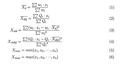
A number of statistical summaries are computed, depending on the science parameter being considered.
Statistics for a given Level-2 measurement might include:
For the daily product, assume that x1, x2, …, xn represent the retrieved pixel values of a Level-2 parameter over a 1 x 1 degree grid box, Qi is the quality flag for each retrieved pixel value, and wi is the weighting factor (1 for the daily case), then the simple statistics are defined as:
In these equations, (1) will be referred to as the 'regular' mean, (2) as the QA weighted mean, (3) as the regular standard deviation, (4) as the QA weighted standard deviation, (5) as the minimum, and (6) as the maximum.
The simple statistics also include daily log regular mean, log standard deviation, log QA mean, and log QA standard deviation. These log quantities are calculated as shown in equations (1 - 4), except that x1, x2, …, xn are replaced by their logarithms.
Regression statistics, based on the pixels within each 1 by 1 degree grid cell, includes the slope, intercept, mean-squared-error (MSE), and the coefficient of determination (R2).
The histograms and joint histograms report the counts of the pixels falling into predetermined numerical intervals.
The pixel counts are used to represent the number of pixels for the parameters which do not have QA flags, while the confidence-histograms-counts are used to represent the number of counts for each parameter that falls within each QA bin (e.g., questionable, good, very good, and total).