

Product Grid
The MODIS Atmosphere Profile (MOD07_L2) product contains data that has
a spatial resolution (pixel size) of 5 x 5 kilometers (at nadir).
Each MOD07_L2 product file covers a five-minute time interval (based on
the start time of each MODIS Level-1B granule), which
means the MOD07_L2 output grid is 270 5-km pixels in width and 406 5-km pixels in length
for nine consecutive granules. Every tenth granule has an output
grid size of 270 by 408 pixels.
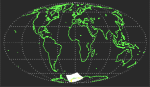
Granule Coverage
The image below depicts MODIS Level-2 granule coverage
during a single simulated orbit. Twenty
consecutive granules are depicted.
It should be noted that a granule of Level-2 MODIS
data is defined as a single Level-2 MODIS product HDF file.


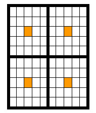
Computation of Geolocation in 5-km L2 Atmosphere Products
The geolocation in the 07_L2 MODIS product is at 5-km resolution. This geolocation is generated from 5x5 1-km L1B input
and is copied from center (3,3) 1-km L1B input pixel in each 5x5-km area.
|