|
|
 |

Collection 006 Known Problems

- Four Minor Corrections including updated Surface Albedo and Alternate Solution Logic (ASL)
 Description:
The following changes entered Aqua forward processing starting on the production date given below. Aqua data generated before the corrected Production Date (noted below) was not reprocessed. Terra was not impacted as Terra processing had not yet begun when the problem was found and fixed.
Description:
The following changes entered Aqua forward processing starting on the production date given below. Aqua data generated before the corrected Production Date (noted below) was not reprocessed. Terra was not impacted as Terra processing had not yet begun when the problem was found and fixed.
- Surface Spectral Albedo Dataset updated through 2013:
The MOD06 ancillary land/snow albedo dataset is an 8-day cadence (16-day average) gap-filled dataset derived from the Collection 5 MOD43 product. With a recent update of the ancillary dataset through 2013, MODAPS is reprocessing all 2013 MOD06 cloud optical property datasets for C6 Aqua. In addition, forward processing (2014 and onward) will use the albedo dataset from the corresponding 2013 time period.
This was found to have minor impact on cloud optical retrievals for a monthly aggregation from a test version of the MODIS Atmosphere Level-3 product.
(Data Impact from this item was of minor consequence)
- Alternate Solution Logic (ASL) algorithm:
Instances occur when the retrieved cloud optical thickness is > 150 and the shortwave infrared (SWIR) or mid-wave infrared (MWIR) channel reflectance is within the valid look-up table (LUT) solution space for cloud effective radii (CER) retrievals. For such pixels, the previous ASL CER solution interpolation routine occasionally defaulted to the closest LUT grid point CER integer value instead of interpolating between the two adjacent LUT grid points. This update now provides interpolated CER. This minor issue generally only occurs at high latitudes and large solar zenith angles.
(Data Impact from this item was of minor consequence)
- Cloud Optical Thickness (1.6 and 3.7 micron retrievals) capped at 150:
A bug fix was implemented to fix a few Cloud Optical Thickness 16 & 37 Retrievals that were beyond the 150 maximum. This was happening for a small number of very bright clouds (typically at low sun angles.
In this new version, all valid COT retrievals fall in the 0 to 150 range.
(Data Impact from this item was of minor consequence)
- New Scattering Parameter SDS attribute:
To improve documentation for Cloud Product (06_L2) data users, local attributes have been added to the 2-dimensional Scattering Property SDSs to provide the MODIS channels and cloud effective radii corresponding to the rows and columns of the datasets. The modified SDSs and their dimensions follow.
Liquid Water Cloud LUT Scattering Parameter SDSs (7 channels x 18 effective radii):
1.) Asymmetry_Parameter_Liq, 2.) Single_Scatter_Albedo_ Liq, 3.) Extinction_Efficiency_Liq
Ice Cloud LUT Scattering Parameter SDSs (7 channels x 12 effective radii):
1.) Asymmetry_Parameter_Ice, 2.) Single_Scatter_Albedo_Ice, 3.) Extinction_Efficiency_Ice
Impact: Low (Minor)
Data Dates Affected: January 2013 - April 2014
Platform Affected: Aqua Only
|

|
|

|
|
PGE Version
|
Production Dates
|
|
PGE Version
|
Production Dates
|
|
≤ PGE06 v6.0.73
|
≤ 2014 110 (4/20/2014)
|
|
≥ PGE06 v6.0.75
|
≥ 2014 111 (4/21/2014)
|
Cloud Optical Thickness (1.6 and 3.7 micron retrieval) Overflow
|
Description: A few Cloud Optical Thickness 16 & 37 Retrievals are outside the expected valid range of 0 to 150. The intended maximum reported value for a successful Cloud Optical Thickness (COT) retrieval was increased from 100 in Collection 5 to 150 in Collection 6 (C6). However the new C6 COT datasets Cloud_Optical_Thickness_16 and Cloud_Optical_Thickness_37 were inadvertently not limited to 150. Therefore, for a small number of very bright clouds (typically at low sun angles), these two COT datasets can exceed 150 or become negative due to an integer overflow (beyond a COT value of 327.67, which corresponds to a packed short integer value of 32767 (the largest I*2 value that can be stored)). Users are advised that if they encounter a COT value in these datasets that is either greater than 150, or less than 0 but not a fill value, then the value should be set back to 150. This minor COT dataset issue has been remedied for Aqua forward processing starting on "Data Date" January 1, 2013 (with an HDF File "Production Date" of 2014 111 or later). Since the problem was found before C6 Terra processing began, no C6 Terra data was impacted.
Impact: Low (Minor)
Data Dates Affected: July 2002 - December 2012
Platform Affected: Aqua Only
|
|
|
|
|
|
PGE Version
|
Production Dates
|
|
PGE Version
|
Production Dates
|
|
≤ PGE06 v6.0.73
|
≤ 2014 110 (4/20/2014)
|
|
(Not Corrected)
|
(Not Corrected)
|
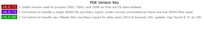
PGE Version History Summary
How to Track MODIS Data File "Versions" (Important for Tracking Problems and Fixes)
Problems and fixes in MODIS Atmosphere Product HDF files can be tracked in one of two ways:
- the Product Generation Executive (PGE) Version Number that can be queried from any HDF file using the command:
ncdump -h *.hdf
- the HDF File "Production Date".
The HDF File "Production Date", which is the date the HDF file was actually generated or produced, can be found in the HDF filename itself (shown in green color below):
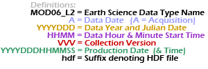
Level 2 Product Names:

|
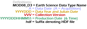
Level 3 Product Names:

|
|
Note that 1.) all times are UTC time, not local time 2.) the DDD in the date denotes the Julian Date (001-366), and 3.) the MOD06_L2 (or MOD08_D3) prefix is only an example (MYD04_L2, MOD05_L2, MYD05_L2, MYD06_L2, etc. ... or MYD08_D3, MOD08_E3, MYD08_E3, MOD08_M3, MYD08_M3 could be substituted).
|
|
|