MODIS Atmosphere
MODIS Atmosphere Home Products  Images  Validation  News  Staff  Forum  Reference  Tools  Help
Aerosol Product  Water Vapor Product  Cloud Product  Atmosphere Profile Product  Cloud Mask Product   Joint Atmosphere ProductLevel-2 Products
Daily Global Product  Eight-Day Global Product  Monthly Global ProductLevel-3 Products       Filled Land Surface Albedo ProductFilled Normalized Difference Vegetative Index ProductOne-Minute Land Ecosystem Classification ProductLevel-3 Ancillary Land Surface Products
MOD05_L2 (Water Vapor Product)
Introduction
Format & Content
Grids & Mapping
DOI
Sample Images
QA Information
Modification History
Acquiring Data
Filename Convention
Analysis Tools
Theoretical Basis
Validation
Detailed File Spec
Algorithm Software
Production Plan
Support Team

Grids & Mapping

Product Grid

The MODIS Water Vapor (MOD05_L2) product contains data that has a spatial resolution (pixel size) of 1 x 1 kilometers (at nadir) or 5 x 5 kilometers (at nadir). Each MOD05_L2 product file covers a five-minute time interval (based on the start time of each MODIS Level-1B granule), which means the MOD05_L2 output grid is 1350 1-km pixels in width and 2030 1-km pixels in length (or 270 by 406 5-km pixels) for nine consecutive granules. Every tenth granule has an output grid size of 1350 by 2040 pixels (or 270 by 408).

Granule Coverage

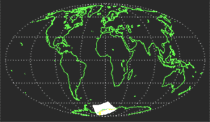
The image below depicts MODIS Level-2 granule coverage during a single simulated orbit. Twenty consecutive granules are depicted. It should be noted that a granule of Level-2 MODIS data is defined as a single Level-2 MODIS product HDF file.


MODIS Level-2 Granule Coverage
Sample Orbital Track and Granule Coverage
Created by Li & Hubanks


Next Page
IMAGES