MODIS Atmosphere
MODIS Atmosphere Home Products  Images  Validation  News  Staff  Forum  Reference  Tools  Help
Aerosol Product  Water Vapor Product  Cloud Product  Atmosphere Profile Product  Cloud Mask Product   Joint Atmosphere ProductLevel-2 Products
Daily Global Product  Eight-Day Global Product  Monthly Global ProductLevel-3 Products       Filled Land Surface Albedo ProductFilled Normalized Difference Vegetative Index ProductOne-Minute Land Ecosystem Classification ProductLevel-3 Ancillary Land Surface Products
Filled Land Surface Albedo Product
Introduction
Format & Content
Grids & Mapping
Frequently Asked Questions
Modification History
Viewing Browse Imagery
Downloading HDF Datafiles
Analysis Tools
Theoretical Basis
Detailed File Spec
Support Team

Grids & Mapping

Equal Angle Grid

All of the Filled Land Surface Albedo Products are stored on an equal angle lat-lon grid. The grid resolution is dependant on the product ranges from 1-minute resolution (2 km at the equator and < 1 km at the pole) to 10°.
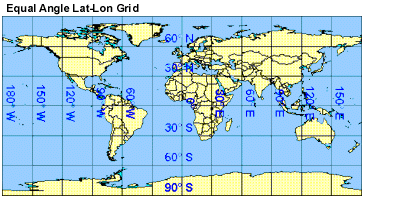
The upper left corner position of the first grid cell (1,1) is located at latitude 90°N and longitude 180°W. The convention used here is degrees north latitude are stored as positive numbers; while degrees west longitudes are stored as negative numbers. This allows lat/lon pairs to increase from top to bottom and left to right on the grid.

Next Page
HISTORY