

Product Description
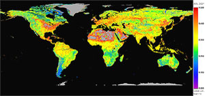 The Filled Land Surface Albedo Product, which is generated from MOD43B3
(the official Terra/MODIS-derived Land Surface Albedo Product, website),
is a global data set of spatially complete albedo maps computed for both "white-sky" and "black-sky"
at 10 wavelengths (0.47µm, 0.55µm, 0.67µm, 0.86µm, 1.24µm, 2.1µm, 0.3-0.7µm, 0.3-5.0µm, and 0.7-5.0µm)
for 23 sixteen-day periods per year (001, 017, ... 353).
There are two types of Filled Land Surface Albedo Products: 1-minute Map Products and coarser resolution Statistical Products.
The Filled Land Surface Albedo Product, which is generated from MOD43B3
(the official Terra/MODIS-derived Land Surface Albedo Product, website),
is a global data set of spatially complete albedo maps computed for both "white-sky" and "black-sky"
at 10 wavelengths (0.47µm, 0.55µm, 0.67µm, 0.86µm, 1.24µm, 2.1µm, 0.3-0.7µm, 0.3-5.0µm, and 0.7-5.0µm)
for 23 sixteen-day periods per year (001, 017, ... 353).
There are two types of Filled Land Surface Albedo Products: 1-minute Map Products and coarser resolution Statistical Products.
Map Products, containing spatially complete land surface albedo data, are generated at 1-minute resolution on an equal-angle grid.
In addition, Map Products containing run-time processing (as well as source MOD43B3) Quality Assurance (QA)
are generated on the same 1-minute resolution grid.
The maps are stored in separate HDF files for each albedo type (white- and black-sky), each wavelength, and each 16-day period.
This format allows the user to have flexibility to download and store only the data absolutely needed.
Statistical Products, which are generated from the Filled Land Surface Albedo Map Products (outlined above),
contain simple statistics (mean, standard deviation, and pixel counts)
generated on equal-angle grids at various coarser resolutions (½, 1, 2, 3, 4, 5, and 10°).
The statistics are computed with and without an ecosystem classification dependency.
Statistics are stored in separate HDF files for each albedo type (white- and black-sky), each 16-day period, and each grid resolution.
This format allows the user to have flexibility to download and store only the data absolutely needed.
It should be noted that these products currently exist for year 2001 (Terra) data only.
Year 2002 (Terra) data is being prepared for release in early 2004.
Research and Application
The availability of global land surface characteristics and albedo data over a wide range of spectral bands and at high spatial resolution has dramatically improved with the launch of the MODIS instrument aboard NASA's Earth Observing System (EOS) spacecraft. However, lack of spatial and temporal coverage due to cloud and snow effects can preclude utilization of official products in production and research studies.
The Filled Land Surface Albedo Product has been developed by employing phenological temporal curve fitting to statistically fill missing data in the official product (MOD43B3)
in order to provide spatially complete global maps. Additionally, statistics of the complete albedo maps at various resolutions, an ecosystem classification, as well as
a Normalized Difference Vegetation Index (NDVI) product computed from the complete albedo maps, are provided.
Spectral land surface albedo is an important parameter for describing the radiative properties of the Earth while the ecosystem classification and NDVI products are important parameters in describing the productivity and characteristics of the land surfaces. These products reflect the consequences of natural and human interactions, such as anthropogenic, meteorological, and phenological effects on local and global climatological trends. Consequently, these products are integral parts in a variety of research areas, such as general circulation models (GCMs), energy balance studies, modeling of land use and land use change, as well as biophysical, oceanographic, and meteorological studies.
Methodology
- Filled Land Surface Albedo Map Product
Several processing steps are required to create the Filled products. First, the official MODIS land surface albedo product, MOD43B3, is remapped from an Integerized Sinusoidal (ISIN) projection to equal-angle rectangular coordinates at 1-minute resolution (2 km at equator, < 1 km at pole). MOD43B3 general and band specific quality assurance (QA) is then applied to the remapped data to remove snow covered pixels and data of insufficient quality. Statistics based upon ecosystem classification are generated at various resolutions from the QA applied maps and the statistical phenological filling algorithm replaces missing data in the QA applied maps and outputs the complete maps into the final HDF storage format.
The statistical phenological filling technique is influenced by the phenological concept that within a certain area, a pixel's ecosystem class should exhibit similar growth cycle events over the same time period. The shape of an area's phenological temporal curve can be imposed upon existing pixel-level data to fill missing temporal points. For full details please see documents in the Theoretical Basis section.
QA is stored separately in the final output in order to eliminate redundancies and reduce the data volume. The MOD43B3 QA consists of general QA, which is applied to both white- and black-sky data for all wavelengths, and band specific QA which is applied to all of the non-broadband data for both white- and black-sky albedo. For each 16-day dataset, the general QA is stored in one HDF file, while the band specific QA is stored in 7 files. Generating the complete albedo maps creates band specific processing QA that can be applied to both white- and black-sky albedo. The processing QA is stored in 10 HDF files, one per wavelength.
- Filled Land Surface Albedo Statistical Product
The statistics are generated by binning the 1-minute complete albedo maps at various resolutions.
The binning grid is equal-angle and cell-centered such that for a 1° grid
the upper left corner grid box contains data from 90 to 89°N latitude and
180 to 179°W longitude.
Statistics are computed from either all the data in a bin, or for each ecosystem class within a bin. QA is not produced for these data sets, as individual pixel level QA information is not combined in the binning process.
Additional Information
Coverage: Global
Temporal Characteristics: 16-day periodicity.
Key Science Applications: GCM, energy balance, land use and land use change, biophysical, oceanographic, and meteorological studies.
Key Geophysical Parameters: White- and Black-Sky Land Surface Albedo (0.47µm, 0.555µm, 0.659µm, 0.858µm, 1.24µm, 1.64µm, 2.1µm, and broadband 0.3-0.7µm, 0.3-5.0µm, 0.7-5.0µm).
Processing Level: 3
Product Type: Unofficial, Derived, Value-Added, Ancillary
Data Format: HDF
- Filled Land Surface Albedo Map Product
Spatial Characteristics: Equal-Angle Rectangular Coordinate grid at 1-minute resolution (2 km at equator, < 1 km at pole).
File Frequency: 20 Product Files/Day (1 per wavelength for both white- and black-sky albedo), 1 MOD43B3 General QA File/Day (applies to both white- and black-sky albedo), 7 MOD43B3 Band Specific QA Files/Day (applies to both white- and black-sky albedo), 10 Processing QA Files/Day (applies to both white- and black-sky albedo).
Maximum File Size: Filled Land Surface Albedo Product File = 445MB, Run-Time Processing QA File = 446MB; MOD43B3 General QA File= 446MB, MOD43B3 Band Specific QA File = 223MB
- Filled Land Surface Albedo Statistical Product
Spatial Characteristics: Equal-Angle Rectangular Coordinate grid at various resolutions (½ to 10°).
File Frequency: 2 Product Files/Day/Resolution (Each file contains all wavelengths for either white- or black-sky albedo)
Maximum File Size: ½° Statistical Product File = 40MB, ½° Ecosystem Dependant Product File = 712MB
(coarser resolution files are significantly smaller)
|